|
 |
 Автор: Williams Автор: Williams
 Дата: 15 июня 2025 Дата: 15 июня 2025
 Просмотров: 317 Просмотров: 317 |
| |
Sensors & Software EKKO_Project 2025 V6 R2.1 build 8238
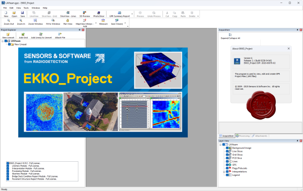
EKKO_Project is the all-inclusive software solution for managing, displaying, processing and interpreting GPR data. Once the Ground Penetrating Radar (GPR) data collection in the field is complete, the next step is to pull out the key information and images and generate a final report. The EKKO_Project software makes complex GPR analysis easy with intuitive tools to organize, edit, process and plot your GPR data. Powerful visualization, analysis and integration tools allow you to quickly and easily produce impressive reports. EKKO_Project consists of a base program with optional modules. The base package provides file organization, quick visualization of your project information in a single window and automated reporting. EKKO_Project works with project .gpz files automatically exported from current GPR systems. An embedded database structure allows all GPR data and ancillary files (GPS, topography, photos, notes, etc.) to be housed in a single .gpz file for a specific project. A project file could contain a single GPR line or several hundred lines from a complex survey. Legacy .dt1 and .hd files can also be imported. Any available project information can easily be added to the .gpz file, providing a single point for all your survey information. |
| |
 Читать статью дальше (комментариев - 1)
| |
|
|
Автор: Williams
Дата: 15 сентября 2021
Просмотров: 1 125 |
| |
Sensors & Software EKKO_Project V6 R1 build 7775

EKKO_Project is the all-inclusive software solution for managing, displaying, processing and interpreting GPR data. Once the Ground Penetrating Radar (GPR) data collection in the field is complete, the next step is to pull out the key information and images and generate a final report. The EKKO_Project software makes complex GPR analysis easy with intuitive tools to organize, edit, process and plot your GPR data. Powerful visualization, analysis and integration tools allow you to quickly and easily produce impressive reports. EKKO_Project consists of a base program with optional modules. The base package provides file organization, quick visualization of your project information in a single window and automated reporting. EKKO_Project works with project .gpz files automatically exported from current GPR systems. An embedded database structure allows all GPR data and ancillary files (GPS, topography, photos, notes, etc.) to be housed in a single .gpz file for a specific project. A project file could contain a single GPR line or several hundred lines from a complex survey. Legacy .dt1 and .hd files can also be imported. Any available project information can easily be added to the .gpz file, providing a single point for all your survey information. |
| |
Читать статью дальше (комментариев - 9)
| |
|
|
Автор: Williams
Дата: 28 апреля 2018
Просмотров: 1 747 |
| |
Sensors & Software EKKO_Project V5 R2 build 7516

EKKO_Project is the all-inclusive software solution for managing, displaying, processing and interpreting GPR data. Once the Ground Penetrating Radar (GPR) data collection in the field is complete, the next step is to pull out the key information and images and generate a final report. The EKKO_Project software makes complex GPR analysis easy with intuitive tools to organize, edit, process and plot your GPR data. Powerful visualization, analysis and integration tools allow you to quickly and easily produce impressive reports. EKKO_Project consists of a base program with optional modules. The base package provides file organization, quick visualization of your project information in a single window and automated reporting. EKKO_Project works with project .gpz files automatically exported from current GPR systems. An embedded database structure allows all GPR data and ancillary files (GPS, topography, photos, notes, etc.) to be housed in a single .gpz file for a specific project. A project file could contain a single GPR line or several hundred lines from a complex survey. Legacy .dt1 and .hd files can also be imported. Any available project information can easily be added to the .gpz file, providing a single point for all your survey information. |
| |
Читать статью дальше (комментариев - 18)
| |
|
|
| ПОИСК ПО САЙТУ |
|
|
|
| КАЛЕНДАРЬ | | |
|
| « Октябрь 2025 » |
|---|
| Пн | Вт | Ср | Чт | Пт | Сб | Вс |
|---|
| | 1 | 2 | 3 | 4 | 5 | | 6 | 7 | 8 | 9 | 10 | 11 | 12 | | 13 | 14 | 15 | 16 | 17 | 18 | 19 | | 20 | 21 | 22 | 23 | 24 | 25 | 26 | | 27 | 28 | 29 | 30 | 31 | |
|
| |
| |
|


