|
 |
 Автор: Williams Автор: Williams
 Дата: 28 мая 2023 Дата: 28 мая 2023
 Просмотров: 4 741 Просмотров: 4 741 |
| |
GeoStru GeoApps 2022-2023
Easy MASW 2022.28.6.999, EasyRefract 2022.21.4.898, ESD 2023.2.1.489, GDW 2022.21.2.1000, GFAS 2022.12.0.857
Liquiter 2022.24.5.1054, PC 2022.14.4.816, RC-SEC 2022.14.1.1061, Slope 2023.30.6.1521, Static Probing 2021.20.2.968
Easy Refract is the a software dedicated to the interpretation of seismic refraction surveys using the reciprocal method and the generalized reciprocal method (G.R.M.) The definition of the array geometry is extremely flexible and does not impose constraints on the number of shots to be used in the analysis.
Easy MASW is a software for the interpretation and archiving of seismic data using the MASW method (Multi-Channel Analysis of Surface Waves). It is a very easy-to-use application that, with simple steps, performs the analysis of the shear waves velocities. The software allows the inversion using more modes. During the spectral processing phase the user can view the dispersion of a customizable synthetic model and the results are plotted directly on the velocity-frequency spectrum. The generation of the velocity-frequency spectrum has been improved to allow a more effective identification of modes. The user can select the points on which the inversion is performed directly on the velocity-frequency spectrum and assign to each point the mode to which it refers.
ESD is a software for the check of earth small dams under both static and seismic conditions.
GDW analyzes walls in gabions, simple concrete weirs and GABIONS weirs in static ad seismic conditions. GDW has advanced graphics features including the three-dimensional view through which you can examine in detail the inputs made. Safety checks are carried out for load combinations defined by the user in accordance with the directives imposed by new regulations.
GFAS (Geotechnical and F.E.M. analysis System) is a product for mechanical analysis of soil using finite elements methods. This is a complete solution that integrates all functions required for the analysis of geotechnical problem areas such as: Tunnels; Slope Stability; Excavations; Embankment settlements; Foundation Settlements; Interaction between structures and soils.
Liquiter software is designed for soil liquefaction analysis and supports a wide variety of field tests. The results of the analysis are presented as: Safety Factor Soil Liquefaction / Probability of Soil Liquefaction; Cyclic mobility of clay; Liquefaction of sand and clay; CSR, variable CSR with depth from SHAKE results; Reconsolidation Settlement, Lateral Spreading; Residual Strength.
PS – advanced, produce una accurata relazione automatica sulla pericolositа sismica di sito:
- Localizzazione automatica del sito.
- Pericolositа sismica di base.
- Pericolositа sismica di sito.
- Storia sismica del sito.
- Rappresentazione degli spettri elastici e di progetto. Calcolo dei coefficienti sismici cinematici ed inerziali.
- Redazione di una accurata relazione di calcolo secondo quanto previsto al C10 Relazioni specialistiche.
- Generazione automatica dei file sismici da importare in altri software GEOSTRU.
RC-SEC is a software for the calculation of reinforced concrete sections according to EN 1992-1-1 and EN 1998-1 and eventual national application annexes. This software is a standalone application for checks of reinforced section belonging to beams, columns and walls. In seismic checks is considered the class of ductility demand (DCL, DCM or DCH) and whether or not the section is within a critical region of the member. If the checks are not seismic you must select the low ductility class (DCL) and so only EN 1992-1-1 is applied.
Slope. This program carries out the analysis of soil or rock slope stability both in static and seismic states utilizing the limit equilibrium methods of Fellenius, Bishop, Janbu, Bell, Sarma, Spencer, Morgenstern & Price and Discrete elements method (DEM) for circular and non circular surfaces by which it is possible to ascertain slippages in the slope, examine a gradual failure, and employ various models of force-deformation relationship. Reinforcements with piles, gravity and/or reinforced concrete bracing walls, nettings, geofabrics, anchors, and terracing may be specified. Distributed and point loads may be defined.
Static Probing is for the processing and archiving static penetration tests with mechanical cone CPT, electric cone CPTE and piezocone CPTU. The lithological and stratigraphic interpretation methods are developed for a step chosen by the user, even centimetric, with the most successful internationally used and recent methodologies (in addition to the historical ones of Begemann and Schmertmann, the software also uses Robertson, Douglas-Olsen, Koester etc. with standard or ”normalized” data of qc and fs) |
| |
 Читать статью дальше (комментариев - 31)
| |
|
 |
 Автор: Williams Автор: Williams
 Дата: 1 апреля 2019 Дата: 1 апреля 2019
 Просмотров: 1 649 Просмотров: 1 649 |
| |
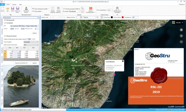
GeoStru RSL-III 2019.20.5.541 ITA repack

Risposta sismica locale RSL III – Software per la valutazione della risposta sismica locale di III livello.
Con il metodo di III livello è possibile valutare puntualmente l’effettiva amplificazione stratigrafica sfruttando la soluzione dell’equazione differenziale che governa il problema della propagazione di onde di taglio in un solido alla Kelvin-Voigt ed un comportamento dei terreni secondo curve di decadimento per G e lo smorzamento tratte dalla letteratura scientifica e/o normative (Regione Lombradia), o ancora, curve di decadimento personalizzate.
La procedura di calcolo utilizzata da RSL III per la risposta sismica locale è di tipo lineare equivalente su un modello di n strati piani e paralleli di estensione orizzontale infinita su un semispazio corrispondente al bedrock.
L’input sismico, rappresentato da uno o più accelerogrammi (REXEL permette la ricerca di combinazioni di accelerogrammi naturali compatibili con gli spettri di normativa), viene applicato al bedrock e viene valutato il moto di propagazione delle onde in direzione perpendicolare alla superficie utilizzando l’equazione di equilibrio dinamico in funzione dello spostamento.
I valori finali forniti dall’analisi di III livello sono gli accelerogrammi e i relativi spettri di risposta, lo spettro medio e quello medio normalizzato da confrontare con lo spettro di normativa. |
| |
 Читать статью дальше (комментариев - 11)
| |
|
 |
 Автор: Williams Автор: Williams
 Дата: 24 марта 2019 Дата: 24 марта 2019
 Просмотров: 1 299 Просмотров: 1 299 |
| |
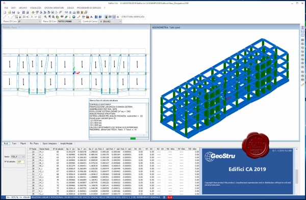
GeoStru Edifici CA 2019.15.0.999

Software di calcolo strutturale edifici multipiano in Cemento Armato – Edifici in C.A. Tra le novità introdotte dalle Norme Tecniche delle Costruzioni si segnala la determinazione delle azioni sismiche (con la previsione di una differente formulazione degli spettri di risposta e valori di accelerazione sismica diversi da sito a sito anche nell’ambito della stessa zona sismica), l’obbligo delle verifiche secondo il principio della gerarchia delle resistenze anche se si opera in bassa duttilità, l’introduzione di un nuovo stato limite (di Operatività) per gli edifici di maggiore importanza, un ulteriore avvicinamento delle verifiche sezionali (agli stati limite) alle modalità previste dalle nuove versioni degli eurocodici: EC2 ed EC8.
Il calcolo si sviluppa risolvendo un telaio tridimensionale con il metodo degli spostamenti, l’utente può scegliere tra diverse tipologie di analisi: Analisi statica non lineare, sismica statica, sismica dinamica (con spettri di risposta). Dimensionamento e Verifica degli Elementi strutturali a presso e tenso-flessione deviata, taglio e torsione, progetto delle armature e delle staffe sia con il Metodo agli Stati Limite (tenendo conto dei Criteri di Gerarchia delle Resistenze) sia alle Tensioni Ammissibili (ancora utilizzabile per i soli edifici ricadenti in zone a bassa sismicità). Tipologie Strutturali di Fondazione – Graticci di travi su suolo elastico alla Winkler, Plinti superficiali (anche a bicchiere) su suolo elastico collegati tra loro da travi semplici o alla Winkler, Platee su suolo elastico semplici e nervate, Pali e micropali anche inclinati, Plinti su pali (predefiniti su 1, 2, 4, 5, 6, 8, 9 pali), Platee semplici o nervate su pali.
Per ogni combinazione di carico vengono visualizzati:
- gli spostamenti dei nodi e le reazioni nei nodi vincolati;
- gli sforzi nelle travi, nei pilastri, nelle pareti nei pali e nei plinti;
- le armature di predimensionamento di travi e pilastri successivamente organizzate nei vari contesti previsti di cui al § 2.4 in cui vengono fornite le disposizioni esecutive e le verifiche dettagliate finali sezione per sezione.
Nel caso di calcolo sismico vengono rappresentati anche i risultati dell’analisi modale. Per ogni periodo proprio selezionato dall’utente vengono visualizzati in tabella gli spostamenti dei nodi (autovettori) nonchè la corrispondente % di massa partecipante nelle direzione X e Y del sisma. Gli stessi spostamenti modali sono rappresentati sia piano per piano nelle piante (grafico 2D) che complessivamente nel grafico assonometrico (3D). Il programma, in accordo alle attuali disposizioni, considera tutte le combinazioni di carico nei riguardi di tutti gli Stati Limite (SLU, SLE) tenendo conto anche delle eccentricità accidentali delle azioni sismiche in entrambe le direzioni d’ingresso del sisma. Si tiene inoltre conto della dimensione finita delle sezioni e dell’ingombro finito dei nodi e degli effetti della fessurazione. |
| |
 Читать статью дальше (комментариев - 12)
| |
|
 |
 Автор: Williams Автор: Williams
 Дата: 22 марта 2019 Дата: 22 марта 2019
 Просмотров: 925 Просмотров: 925 |
| |
GeoStru RSL-III 2019.20.5.541 ITA

Risposta sismica locale RSL III – Software per la valutazione della risposta sismica locale di III livello.
Con il metodo di III livello è possibile valutare puntualmente l’effettiva amplificazione stratigrafica sfruttando la soluzione dell’equazione differenziale che governa il problema della propagazione di onde di taglio in un solido alla Kelvin-Voigt ed un comportamento dei terreni secondo curve di decadimento per G e lo smorzamento tratte dalla letteratura scientifica e/o normative (Regione Lombradia), o ancora, curve di decadimento personalizzate.
La procedura di calcolo utilizzata da RSL III per la risposta sismica locale è di tipo lineare equivalente su un modello di n strati piani e paralleli di estensione orizzontale infinita su un semispazio corrispondente al bedrock.
L’input sismico, rappresentato da uno o più accelerogrammi (REXEL permette la ricerca di combinazioni di accelerogrammi naturali compatibili con gli spettri di normativa), viene applicato al bedrock e viene valutato il moto di propagazione delle onde in direzione perpendicolare alla superficie utilizzando l’equazione di equilibrio dinamico in funzione dello spostamento.
I valori finali forniti dall’analisi di III livello sono gli accelerogrammi e i relativi spettri di risposta, lo spettro medio e quello medio normalizzato da confrontare con lo spettro di normativa. |
| |
 Читать статью дальше (комментариев - 7)
| |
|
 |
| ПОИСК ПО САЙТУ |
 |
|
 |
| КАЛЕНДАРЬ | | |
 |
| « Октябрь 2025 » |
|---|
| Пн | Вт | Ср | Чт | Пт | Сб | Вс |
|---|
| | 1 | 2 | 3 | 4 | 5 | | 6 | 7 | 8 | 9 | 10 | 11 | 12 | | 13 | 14 | 15 | 16 | 17 | 18 | 19 | | 20 | 21 | 22 | 23 | 24 | 25 | 26 | | 27 | 28 | 29 | 30 | 31 | |
|
 | |
| |
|