|
 |
 Автор: Williams Автор: Williams
 Дата: 25 августа 2022 Дата: 25 августа 2022
 Просмотров: 2 168 Просмотров: 2 168 |
| |
Trimble Tekla Structures 2022 SP3 build 17842

Tekla Structures - комплексное решение, которое позволяет значительно увеличить производительность проектирования промышленных и гражданских зданий с использованием различных конструкционных материалов, таких как: металлоконструкции, сборные железобетонные изделия и монолитные бетонные конструкции.
Tekla Structures представляет собой программное обеспечение информационного моделирования зданий (BIM), которое позволяет создавать точные, подробные, удобные для конструирования 3D модели из любого материала и любой сложности и управлять ими. Модели Tekla Structures можно использовать во всем процессе строительства от эскизов до производства, монтажа и управления строительными работами.
Tekla Structures можно использовать с другими существующими приложениями или отдельно как платформу для разработки собственных рабочих процессов. Открытая платформа поддерживает совместимость и стандартизацию. Tekla Structures стыкуется с различными системами через Tekla Open API через программный интерфейс приложения, который внедряется с использованием технологии Microsoft.NET. Например, Tekla Structures поддерживает следующие стандартные форматы: IFC, CIS/2, SDNF и DSTV. Tekla Structures поддерживает собственные форматы, например DWG, DXF и DGN.
Конфигурации Tekla Structures:
- Tekla Structures, Full Detailing представляет собой универсальную конфигурацию, содержащую модули деталировки металлических конструкции, сборных железобетонных изделий и монолитных бетонных издели. Предусмотрено создание трехмерных моделей конструкций из стали и бетона, а также автоматическая генерация чертежей КМ и КМД.
- Tekla Structures, Steel Detailing представляет собой конфигурацию, предназначенную для проектирования металлоконструкций. Пользователь может создавать детальные трехмерные модели любых металлических конструкций и получать соответствующие данные для производства и мантажа, используемые всеми участниками проекта.
- Tekla Structures, Precast Concrete Detailing представляет собой стандартную конфигурацию, дополненную важными функциями деталировки сборных железобетонных конструкций. Пользователь может создавать детальные трехмерные модели бетонных конструкций и получать соответствующие данные по производству и монтажу, используемые совместно со всеми участниками проекта.
- Tekla Structures, Reinforced Concrete Detailing представляет собой стандартную конфигурацию, дополненную важными функциями деталировку монолитных железобетонных изделий. Пользователь может создавать детальные трехмерные модели монолитных железобетонных изделий и получать соответствующие данные по производству и монтажу, используемые совместно со всеми участниками проекта.
- Tekla Structures, Engineering представляет собой стандартную конфигурацию, позволяющую выполнять синхронизированное конструирование. Проектировщики металлоконструкций и инженеры, проектирующие внутренние инженерные системы, могут сотрудничать в рамках совместно используемой модели.
|
| |
 Читать статью дальше (комментариев - 14)
| |
|
|
Автор: Williams
Дата: 21 августа 2022
Просмотров: 878 |
| |
Aquaveo Groundwater Modeling System Premium v10.6.6 x64

Aquaveo GMS - комплексная среда моделирования подземных вод с системой предварительной графический обработки информации. Aquaveo GMS легко взаимодействует с MODFLOW и рядом других моделей по моделированию подземных вод и предоставляет расширенные графические возможности для просмотра и калибровки результатов моделирования.
|
| |
Читать статью дальше (комментариев - 8)
| |
|
|
Автор: Williams
Дата: 20 августа 2022
Просмотров: 3 556 |
| |
GEO-SLOPE GeoStudio 2021 R4 v11.3.2.23783

GEO-SLOPE GeoStudio - программный комплекс для решения инженерно-геологических задач и моделирования грунтовых конструкций. Данны пакет состоит из 8 продуктов: SLOPE/W - анализ устойчивости откосов; QUAKE / W - динамический анализ землетрясения; AIR / W - анализ потока воздуха; SEEP / W - анализ просачивания грунтовых вод; TEMP / W - геотермальный анализ; VADOSE/W - анализ зон аэрации и анализ почвенного покрова; SIGMA / W - анализ напряженно-деформированного состояния; CTRAN / W - анализ загрязнений транспорта.
GeoStudio is a product suite for geotechnical and geo-environmental modeling, broad enough to handle all your modeling needs. The suite consists of 8 products: SLOPE/W for slope stability; SEEP/W for groundwater seepage; SIGMA/W for stress-deformation; QUAKE/W for dynamic earthquake; TEMP/W for geothermal; CTRAN/W for contaminant transport; AIR/W for air flow; VADOSE/W for vadose zone & covers.
Examples can be found here |
| |
Читать статью дальше (комментариев - 32)
| |
|
|
Автор: Williams
Дата: 19 августа 2022
Просмотров: 2 149 |
| |
Golden Software Grapher v20.1.251 x64

Golden Software Grapher - мощный и одновременно простой в использовании графический пакет, позволяющий быстро создавать высококачественные графики. Grapher позволяет строить более 54 видов двухмерных и трёхмерных графиков. Кроме того, вы можете настраивать любую часть графика или создавать свои собственные графики, наилучшим образом описывающие ваши данные. Программа содержит 4 типа двухмерных графиков: линейные, столбчатые, полярные и специальные. Все эти типы графиков доступны и в трёхмерном исполнении. Если вам требуется отразить дополнительную переменную, вы можете воспользоваться графиками 3D XYZ, контурными картами или картами поверхности.
Спецификации Grapher:
- Разноцветные столбчатые и пузырьковые диаграммы.
- Градиентная заливка для всех объектов.
- На графиках 3D XYZ можно добавлять вертикальные линии сетки.
- Настройка любой части графика под вашу уникальную ситуацию.
- Простое создание своих собственных пользовательских графиков с помощью мастера.
- Создание шаблонов и их сохранение для использования на других графиках.
- Разбиение длинных подписей к осям.
- Автоматизация процесса постороения графиков.
- Запись процессов графика внутри сценария.
- Экспортирование графиков для использования в презентации и публикации в одном из многочисленных форматов, в том числе векторных PDF, EMF, EPS и т.д.
|
| |
Читать статью дальше (комментариев - 7)
| |
|
|
Автор: Williams
Дата: 18 августа 2022
Просмотров: 2 058 |
| |
Trimble Tekla Portal Frame & Connection Designer (Fastrak) 2021 v21.1.0
with the new extended keygen (+1 year)
 2021 v21.1.0")
Tekla Portal Frame Designer is now an integrated part of the Tekla software family. Integrating seamlessly with Tekla Structural Designer or acting as a stand alone application, Tekla Portal Designer is packed full of features and functionality that enable efficient and rigorous design to create cost effective design solutions for steel portal frame buildings. Trusted by UK Structural Engineers for portal frame design for over 30 year the product retains its unique elastic-plastic analysis approach to efficiently create single and multi-bay portal frame designs. Automated checks for sway, member stability and snap through are included along with automated loading for wind, snow, cranes, ties and parapets. Final designs can be communicated through clear and concise documentation that includes drawing and calculations.
Analysis and Design features:
- Easily produce both preliminary and detailed portal frame design options.
- Understand hinge history of the frame including hinge reversal and spurious mechanisms.
- Fully interactive member stability checks.
- Automate frame sway stability checks (including SCI P292 full second order elastic-plastic analysis).
- Integrate eaves, apex and base plate connections to BCSA/SCI Green Book.
Modelling features:
- Build your own steel portal frame.
- Choose from symmetric, asymmetric, propped, monopitch, mansards or flat top portal frames.
- Include valley beams, ties, cranes, floor beams and parapets as required.
- Select from pinned, fixed or partially fixed base conditions.
- Optimise haunches from rolled sections or plated sections.
Loading features:
- Apply dead and imposed load cases automatically.
- Calculate wind loading and snow loading to BS6399 automatically
- Easily apply notional horizontal loading for sway stability.
|
| |
Читать статью дальше (комментариев - 23)
| |
|
|
Автор: Williams
Дата: 17 августа 2022
Просмотров: 17 488 |
| |
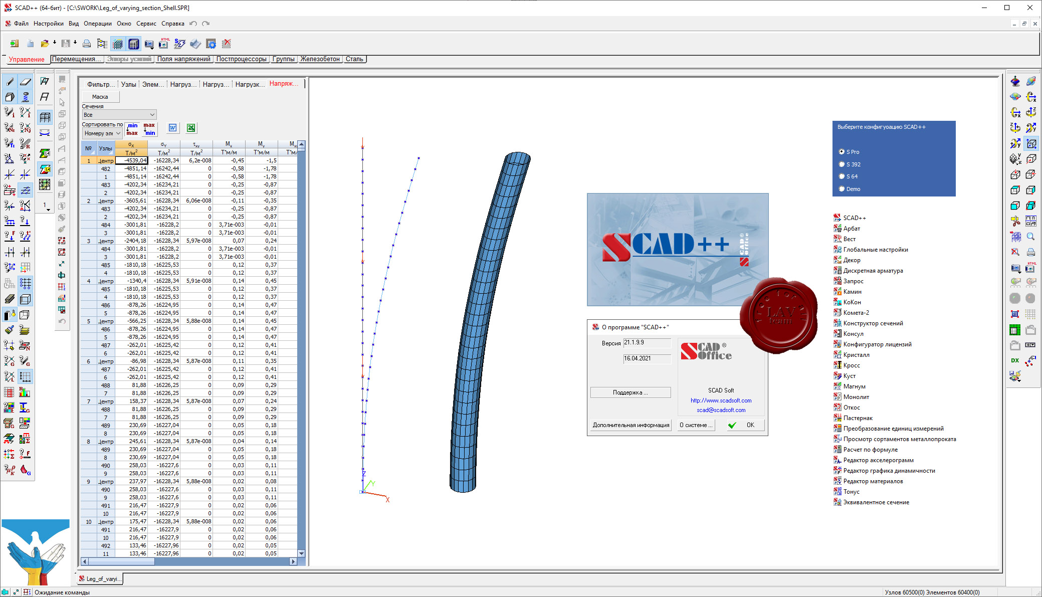
SCAD (Structure CAD) Office v21.1.9.9 build 16/04/2021
full commercial crack

SCAD Office - система нового поколения, разработанная инженерами для инженеров и реализованная коллективом опытных программистов. В состав системы входит высокопроизводительный вычислительный комплекс SCAD, а также ряд проектирующих и вспомогательных программ, которые позволяют комплексно решать вопросы расчета и проектирования стальных и железобетонных конструкций. Система постоянно развивается, совершенствуются интерфейс пользователя и вычислительные возможности, включаются новые проектирующие компоненты.
SCAD Office сертифицирован на соответствие ГОСТ Р ИСО/МЭК 9126-93, ГОСТ 28195-89, ГОСТ Р ИСО 9127-94, РД 50-34.698-90
Соответствие СНиП подтверждено сертификатом Госстроя России.
SCAD Office включает следующие программы:
- SCAD - вычислительный комплекс для прочностного анализа конструкций методом конечных элементов
- КРИСТАЛЛ - расчет элементов стальных конструкций
- АРБАТ - подбор арматуры и экспертиза элементов железобетонных конструкций
- КАМИН - расчет каменных и армокаменных конструкций
- ДЕКОР - расчет деревянных конструкций
- ЗАПРОС - расчет элементов оснований и фундаментов
- ОТКОС - анализ устойчивости откосов и склонов
- ВЕСТ - расчет нагрузок по СНиП "Нагрузки и воздействия" и ДБН
- МОНОЛИТ - проектирование монолитных ребристых перекрытий
- КОМЕТА, КОМЕТА-2 - расчет и проектирование узлов стальных конструкций
- КРОСС - расчет коэффициентов постели зданий и сооружений на упругом основании
- КОНСТРУКТОР СЕЧЕНИЙ - формирование и расчет геометрических характеристик сечений из прокатных профилей и листов
- КОНСУЛ - построение произвольных сечений и расчет их геометрических характеристик на основе теории сплошных стержней
- ТОНУС - построение произвольных сечений и расчет их геометрических характеристик на основе теории тонкостенных стержней
- СЕЗАМ - поиск эквивалентных сечений
- КоКон - справочник по коэффициентам концентрации напряжений и коэффициентам интенсивности напряжений
- КУСТ - расчетно-теоретический справочник проектировщика
|
| |
Читать статью дальше (комментариев - 72)
| |
|
|
| ПОИСК ПО САЙТУ |
|
|
|
| КАЛЕНДАРЬ | | |
|
| « Октябрь 2025 » |
|---|
| Пн | Вт | Ср | Чт | Пт | Сб | Вс |
|---|
| | 1 | 2 | 3 | 4 | 5 | | 6 | 7 | 8 | 9 | 10 | 11 | 12 | | 13 | 14 | 15 | 16 | 17 | 18 | 19 | | 20 | 21 | 22 | 23 | 24 | 25 | 26 | | 27 | 28 | 29 | 30 | 31 | |
|
| |
| |
|


 2021 v21.1.0")