|
 |
 Автор: Williams Автор: Williams
 Дата: 30 июня 2023 Дата: 30 июня 2023
 Просмотров: 273 Просмотров: 273 |
| |
Hexagon (ex. Vero, ex. Planit) Edgecam Suite 2022.0

Edgecam - автоматизированное создание управляющих программ для станков с ЧПУ. Разработка принадлежит англиЦкой компании Pathtrace Technology, которая, в свою очередь, является подразделением группы Planit Holdings plc, специализирующейся на создании CAD/CAM систем мирового класса, ориентированных на машиностроение, деревообработку, мебельную промышленность и розничную торговлю.
Planit Edgecam является ведущим международным партнером по САМ-системам компании Autodesk - Global Preferred Computer Aided Manufacturing (CAM) Partner. Помимо этого, Planit Edgecam имеет статус Сертифицированного Приложения для SolidWorks, Autodesk Inventor и Solid Edge.
Модули Planit Edgecam позволяют осуществлять призматическую и поверхностную фрезерную обработку, сложную токарную обработку по нескольким осям, простую фрезерную или токарную обработку, ротационную и многопозиционную фрезерную обработку, обработку целых групп деталей и комплектующих.
Библиотека инструментов повышения производительности Planit Edgecam Productivity Toolbox представляет собой целый набор функций, повышающих эффективность работы с программой. Среди них отличные возможности для моделирования траектории обработки, уникальный мастер постпроцессоров, современная библиотека инструментов, интуитивные и гибкие коммуникации с оборудованием, система управления работой на основе web.
Благодаря Edgecam Solid Machinist, мощной системе, интегрированной в пакет Edgecam, компания Pathtrace занимает лидирующие позиции на рынке CAD/CAM.
Модуль Edgecam Solid Machinist позволяет загружать файлы Autodesk Inventor, Pro/ENGINEER, SolidWorks, Solid Edge CATIA V5 напрямую в Edgecam. |
| |
 Читать статью дальше (комментариев - 3)
| |
|
|
Автор: Williams
Дата: 29 июня 2023
Просмотров: 2 257 |
| |
Arqcom CAD-Earth v8.0.3 for AutoCAD 2021-2024
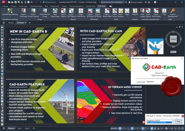
CAD-Earth is designed to easily import/export images, objects and terrain meshes between Google Earth and major CAD programs and create dynamic contour lines and profiles.
Features:
- Import Google Earth image to CAD.
- Export CAD screenshot to Google Earth.
- Insert georeferenced images.
- Import Google Earth objects to CAD.
- Export CAD objects to Google Earth.
- Import Google Earth terrain.
- More than 3000 supported coordinate systems worldwide.
- Cross section from mesh.
- Profile from mesh.
|
| |
Читать статью дальше (комментариев - 25)
| |
|
|
Автор: Williams
Дата: 28 июня 2023
Просмотров: 601 |
| |
dGB Earth Sciences OpendTect v7.0.0 Windows + Linux

OpendTect is a free, open source seismic interpretation system and software development platform. The system supports all tools needed for visualizing, analyzing and interpreting 2D, 3D and 4D seismic data. It is widely used for Geo-Radar interpretation as well.
dGB's software products can be split into two parts: open source and closed source.
The open source part is OpendTect, a seismic interpretation software system for processing, visualizing and interpreting multi-volume seismic data, and for fast-track development of innovative interpretation tools.
The closed source part starts with OpendTect Pro, a commercial layer on top of OpendTect with a lot of extra functionalities, especially for professionals. OpendTect Pro can be extended by renting or purchasing commercial plugins that offer unique seismic interpretation workflows. |
| |
Читать статью дальше (комментариев - 7)
| |
|
|
Автор: Williams
Дата: 26 июня 2023
Просмотров: 633 |
| |
TopSolid 2023 SP3 v7.17.400.67

TopSolid является CAD/CAM/CAE&PDM интегрированной параметрической системой высокого уровня, охватывающая весь процесс проектирования и производства в масштабах предприятия.
С помощью Missler TopSolid Вы можете:
- создавать CAD-модели и чертежи деталей и сборок;
- проводить кинематический и МКЭ (FEM) анализы;
- проектировать пресс-формы, штампы, электроды, работать с листовыми материалами;
- получать развертки и осуществлять раскрой;
- конструировать мебель и изделия из дерева;
- строить системы трубопроводов;
- передавать данные между отдельными модулями системы, осуществлять импорт/экспорт данных из других систем;
- получать управляющие программы для станков с ЧПУ (токарная, фрезерная, многоосевая обработка, лазерная и газо-плазменная резки, электроэрозионная прошивка и вырезка, контроль по программе на координатно-измерительных машинах);
- вводить данные с помощью координатно-измерительных машин (КИМ), а также использовать обширные библиотеки стандартных деталей, агрегатов и инструмента.
Модули Missler TopSolid:
- TopSolid'Design - интегрированное решение для создания СAD моделей и чертежей.
- TopSolid'Mold - интегрированное решение для создания и разработки пресс-форм.
- TopSolid'Progress - интегрированное решение для проектирования и разработки штампов.
- TopSolid'Electrode - интегрированное решение для проектирования электродов.
- TopSolid'PunchCut - интегрированное решение для создания управляющих программ ЧПУ для вырубки, лазерной, плазменной резки и резки водоабразивным составом.
- TopSolid'Wire - интегрированное решение для электроэрозионной резки проволочным электродом.
- TopSolid'Cam - интегрированное решение для создания управляющих программ для станков с ЧПУ.
- TopSolid'Castor - интегрированное решение для анализа методом конечных элементов (FEM - анализ).
- TopSolid'Control - модуль для проведения измерений на трехкоординатных измерительных машинах с ЧПУ.
- TopSolid'Wood - модуль для проектирования изделий из дерева (мебель, деревянные конструкции ...).
- TopSolid'Pdm - интегрированный модуль для управления данными проекта.
- TopSolid'Erp - модуль для оперативного планирования процесса производства.
|
| |
Читать статью дальше (комментариев - 7)
| |
|
|
Автор: Williams
Дата: 25 июня 2023
Просмотров: 280 |
| |
BioSolvetIT SeeSAR v13.0.0 Windows64 + Linux64

SeeSAR fosters innovation during every step of your drug design process. The app includes all tools vital for handling your compounds and target structures which have been fine-tuned to the needs of any chemist. Helpful features such as ADME properties assessment, comprehensive color coding, unoccupied binding pocket visualization, and many others, support you in making sound and interactive decisions. All our tools are based on solid and transparent science cited in over a thousand publications. Follow the button if you want to learn more about the science behind SeeSAR.
Drag and drop your protein, or search comfortably in an online database. Within seconds, your target is prepared and you can get started.
Modify your protein according to your needs. Explore rotamers, introduce mutations, and customize side chains.
SeeSAR automatically detects the binding site of a ligand for you. In addition, you can precisely expand it by adding individual residues — or with a single click to find empty pockets in your protein.
Modify molecules to your taste in 2D or 3D on-the-fly. Once you are done, the molecules are directly prepared for your tasks.
Estimate affinities and interpret the results using the visualized HYDE score. Filter your compounds for relevant parameters, calculate ADME properties, and gain full control over ligand-target interactions.
Ideate without limits! Discover new scaffolds, explore, and grow into free cavities, or link molecules using fragment libraries for elegant solutions.
Dock your compounds with one single click! Screen libraries for actives, and instinctively evaluate your results.
Align your compounds without the need of a target structure based on their molecular similarity.
|
| |
Читать статью дальше (комментариев - 7)
| |
|
|
Автор: Williams
Дата: 23 июня 2023
Просмотров: 1 639 |
| |
Aspen Technology Subsurface Science & Engineering Suite 2023 V14.1 build 26.05.2023

Emerson PARADIGM is now Aspen Technology Subsurface Science & Engineering Suite.
Subsurface Science & Engineering is end-to-end geoscience and modeling solutions for optimization across subsurface engineering and operations. Empower decision makers to reduce uncertainty, improve confidence, minimize risk and support responsible asset management.
We are pleased to announce the availability of the aspenONE Subsurface Science and Engineering (SSE) Suite V14.1 release. This release is an update of the AspenTech SSE product suite (previously Emerson E&P Software), and integrates all AspenTech SSE products into a single offering.
The following products are included in this release: Aspen Epos, Aspen Echos, Aspen GeoDepth, Aspen EarthStudy 360, Aspen SeisEarth (includes QSI and Explorer), Aspen Geolog, Aspen METTE, Aspen OpsLink, Aspen ResView, Aspen RMS, Aspen SKUA (includes StratEarth), Aspen Sysdrill, Aspen Tempest. |
| |
Читать статью дальше (комментариев - 20)
| |
|
|
Автор: Williams
Дата: 21 июня 2023
Просмотров: 1 257 |
| |
Geotic Apps 2023
GeoticCad v1.11.2, GeoticLog v8.2.12 RC2, GeoticMine v1.4.8, GeoticSection v1.0.8

Geotic - quality geological software designed by geologists for geologists.
GeoticLog application is used to input survey information. Its user-friendly interface greatly accelerates data input by allowing users to enter titles, summaries and even typical descriptions with the help of dictionaries. These dictionaries, which are edited by the users themselves, allow data to be validated when input, minimizing the need for subsequent corrections and ensuring exceptional data quality at all times. The information is input and organized in a simple and logical way, making the work even easier. The application also generates personalized reports according to your needs. Similarly, strip logs can be created. The application includes a users’ rights management interface to control data access and make data secure. Data is saved in Access or SQL format and organized in an intuitive schematic diagram, making it easier to produce charts and thematic plans. These databases can then be used by GeoticGraph to create sections and plan views or they can even be exported to other applications. GeoticLog database is directly linked to GeoticMine, which allow to go back and forth easily. Lastly, modules for batch imports/exports, calculating composites, calculating adjusted structures, and QAQC and drilling core photo management integrate with your environment and greatly increase the application’s potential.
GeoticSection allows plans and section books visualization created from your Geotic database. It replaced GeoticGraph in 2022. As its predecessor, GeoticSection offers all the flexibility and the functionalities you need to create quality sections, and much more. This with the same simplicity as GeoticMine. Directly synchronized to GeoticLog, allows importation of 2D section profiles from GeoticSection and GeoticMine.
GeoticMine is the ideal tool for complex 3D geological modelling directly from Geotic databases. Our latest addition supports all the features and objects in our three other software application. It is currently the only modelling software that connects a specific point on drill hole trace in a 3D environment with a linearized and geo-referenced photograph in real time. The effect is striking. Models can be made using sets of polylines and tie lines or automated procedures based on 3D Delaunay-Voronoi triangulation, or a combination of both. GeoticMine also include all the features needed for the volumetric integration and interrogation of block models created by geostatic software such as Isatis, Vulcan, Gemcom or Datamine. In addition to its advanced modelling capabilities, GeoticMine enables you to create vertical, inclined or horizontal sections and projections with the simplicity and ease-of-use that Geotic products are known far. Drill hole planning in a 3D graphics environment that takes historic deviations into account is a practical tool that our clients will certainly appreciate.
The GeoticCAD application is designed to interpret and add the finishing touches to section drawings created by GeoticSection. Similar to AutoCAD, GeoticCAD will provide you with a familiar work environment, thus reducing your learning curve. The software stands out from many competitor products thanks to its own integrated drawing motor. You do not need to install AutoCAD, which translates into increased autonomy and reduced costs. Not only does GeoticCAD work with all the formats supported by GeoticGraph (JPG, PNG, DWG, TIF, PGN…), but its main strength lies in the use of Geotic’s own VDML file format, which optimizes your possibilities. For example, several sections can be combined simply and automatically into one drawing without having to worry about insertion points. Complicated rotations will be a thing of the past since GeoticCAD automatically recognizes all the systems (World, Measure and Plot) defined when creating sections with GeoticGraph, and allows you to move from one system to another with a simple click. It is easy to visualize individual sections when you add your geological interpretation, by making the neighbouring section/s appear in grey. You can complete your drawing by including an arrow pointing north, a graphical scale or a legend explaining the colour codes used when creating your sections or by importing graphical elements from other sources such as AutoCAD or Gemcom. |
| |
Читать статью дальше (комментариев - 13)
| |
|
|
| ПОИСК ПО САЙТУ |
|
|
|
|


