Автор: Williams Дата: 29 июня 2023
Просмотров: 2 069
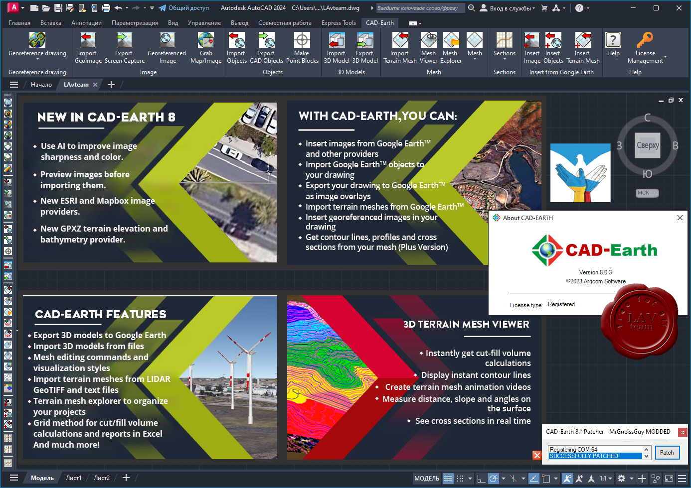
Arqcom CAD-Earth v8.0.3 for AutoCAD 2021-2024
CAD-Earth is designed to easily import/export images, objects and terrain meshes between Google Earth and major CAD programs and create dynamic contour lines and profiles.
Features:
Import Google Earth image to CAD.
Export CAD screenshot to Google Earth.
Insert georeferenced images.
Import Google Earth objects to CAD.
Export CAD objects to Google Earth.
Import Google Earth terrain.
More than 3000 supported coordinate systems worldwide.
Автор: Williams Дата: 23 сентября 2021
Просмотров: 2 227
ArqCOM CivilCAD Suite build September, 2021
for AutoCAD, BricsCAD, ZWCAD
CivilCAD, creado por ARQCOM, es el software diseñado para crear funciones adicionales que automatizan y simplifican las tareas dentro de AutoCAD Full, Bricscad PRO y ZWCAD+ Professional, cubriendo diversas necesidades del profesional de la Ingeniería Civil y Topografía de habla hispana; utilizado por dependencias de gobierno, constructoras y universidades.
Con CivilCAD, puede obtener rápidamente perfiles, secciones, curvas de nivel, cálculo de volúmenes en plataformas y vialidades, cuadros de construcción, subdivisión de polígonos, entre otras más de 100 rutinas.
La licencia base de CivilCAD sólo incluye rutinas de topografía básica (ver rutinas). Existen 6 módulos adicionales que agregan rutinas especializadas a su licencia base de CivilCAD y son:
Cálculo de Redes de Agua Potable
Cálculo de Redes de Alcantarillado
Diseño de Carreteras SCT
Exportación de Datos al Programa Curva Masa SCT
Cálculo de Redes de Alcantarillado Pluvial ADSInterfase con Google Earth
Автор: Williams Дата: 19 сентября 2021
Просмотров: 4 124
Arqcom CAD-Earth v7.0.2 for AutoCAD 2018-2022
CAD-Earth is designed to easily import/export images, objects and terrain meshes between Google Earth and major CAD programs and create dynamic contour lines and profiles.
Features:
Import Google Earth image to CAD.
Export CAD screenshot to Google Earth.
Insert georeferenced images.
Import Google Earth objects to CAD.
Export CAD objects to Google Earth.
Import Google Earth terrain.
More than 3000 supported coordinate systems worldwide.
Автор: Williams Дата: 23 октября 2020
Просмотров: 4 198
Arqcom CAD-Earth v6.1.9 for AutoCAD 2017-2021,BricsCAD 19-20
CAD-Earth is designed to easily import/export images, objects and terrain meshes between Google Earth and major CAD programs and create dynamic contour lines and profiles.
Features:
Import Google Earth image to CAD.
Export CAD screenshot to Google Earth.
Insert georeferenced images.
Import Google Earth objects to CAD.
Export CAD objects to Google Earth.
Import Google Earth terrain.
More than 3000 supported coordinate systems worldwide.
Автор: Williams Дата: 19 октября 2020
Просмотров: 4 000
ArqCOM CivilCAD Suite build October, 2020
for any version ofAutoCAD,ZWCAD,BricsCAD
CivilCAD, creado por ARQCOM, es el software diseñado para crear funciones adicionales que automatizan y simplifican las tareas dentro de AutoCAD Full, Bricscad PRO y ZWCAD+ Professional, cubriendo diversas necesidades del profesional de la Ingeniería Civil y Topografía de habla hispana; utilizado por dependencias de gobierno, constructoras y universidades.
Con CivilCAD, puede obtener rápidamente perfiles, secciones, curvas de nivel, cálculo de volúmenes en plataformas y vialidades, cuadros de construcción, subdivisión de polígonos, entre otras más de 100 rutinas.
La licencia base de CivilCAD sólo incluye rutinas de topografía básica (ver rutinas). Existen 6 módulos adicionales que agregan rutinas especializadas a su licencia base de CivilCAD y son:
Автор: Williams Дата: 22 марта 2020
Просмотров: 5 965
Arqcom CAD-Earth v6.0.8/6 for AutoCAD 2019-2020
CAD-Earth is designed to easily import/export images, objects and terrain meshes between Google Earth and major CAD programs and create dynamic contour lines and profiles.
Features:
Import Google Earth image to CAD.
Export CAD screenshot to Google Earth.
Insert georeferenced images.
Import Google Earth objects to CAD.
Export CAD objects to Google Earth.
Import Google Earth terrain.
More than 3000 supported coordinate systems worldwide.
Автор: Williams Дата: 30 июня 2019
Просмотров: 4 892
Arqcom CAD-Earth v6.0 for AutoCAD 2019-2020
CAD-Earth is designed to easily import/export images, objects and terrain meshes between Google Earth and major CAD programs and create dynamic contour lines and profiles.
Features:
Import Google Earth image to CAD.
Export CAD screenshot to Google Earth.
Insert georeferenced images.
Import Google Earth objects to CAD.
Export CAD objects to Google Earth.
Import Google Earth terrain.
More than 3000 supported coordinate systems worldwide.
Автор: Williams Дата: 29 июня 2019
Просмотров: 3 435
Arqcom CAD-Earth v5.1.22 for AutoCAD 2010-2020,BricsCAD v15-19,ZWCAD 2014-2018
CAD-Earth is designed to easily import/export images, objects and terrain meshes between Google Earth and major CAD programs and create dynamic contour lines and profiles.
Features:
Import Google Earth image to CAD.
Export CAD screenshot to Google Earth.
Insert georeferenced images.
Import Google Earth objects to CAD.
Export CAD objects to Google Earth.
Import Google Earth terrain.
More than 3000 supported coordinate systems worldwide.
Автор: Williams Дата: 9 сентября 2016
Просмотров: 12 592
Arqcom CAD-Earth v5.1 for AutoCAD 2010-2017,BricsCAD v14-16
CAD-Earth is designed to easily import/export images, objects and terrain meshes between Google Earth and major CAD programs and create dynamic contour lines and profiles.
Features:
Import Google Earth image to CAD.
Export CAD screenshot to Google Earth.
Insert georeferenced images.
Import Google Earth objects to CAD.
Export CAD objects to Google Earth.
Import Google Earth terrain.
More than 3000 supported coordinate systems worldwide.
Автор: Williams Дата: 16 ноября 2015
Просмотров: 3 306
Arqcom CAD-Earth v4.1.9 for AutoCAD 2007-2016,ZWCAD+ 2014-2015,BricsCAD v14-15
CAD-Earth is designed to easily import/export images, objects and terrain meshes between Google Earth and major CAD programs and create dynamic contour lines and profiles.
Features:
Import Google Earth image to CAD.
Export CAD screenshot to Google Earth.
Insert georeferenced images.
Import Google Earth objects to CAD.
Export CAD objects to Google Earth.
Import Google Earth terrain.
More than 3000 supported coordinate systems worldwide.
Cross section from mesh.
Profile from mesh.
CAD-Earth for other AutoCAD versions can be downloaded fromhere.